The Friday Post · No. 2
The Great Basin
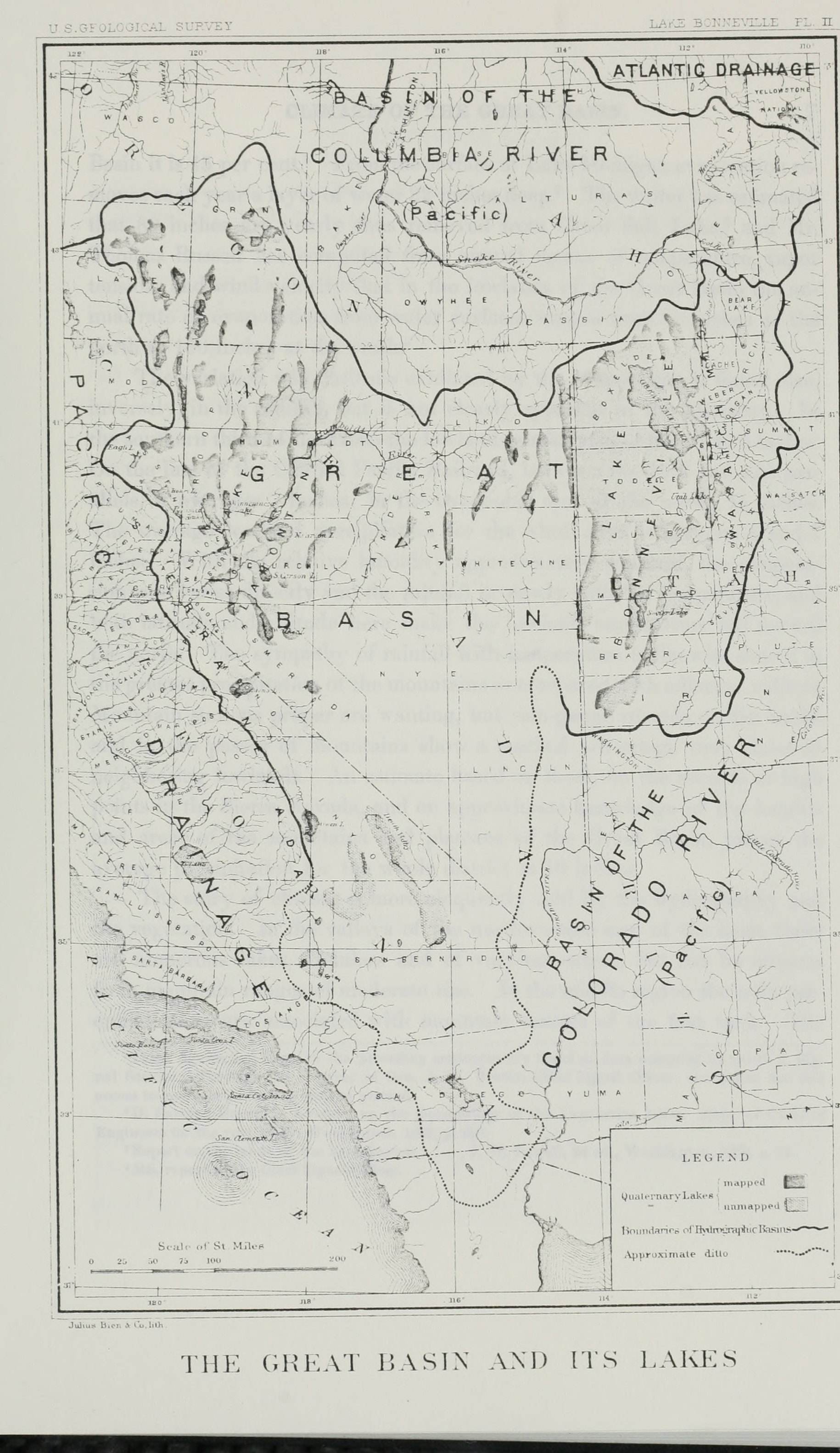
On October 13, 1843, John Charles Frémont was camped at latitude 44° 17′ 36″, longitude 116° 56′ 45″, 1,880 feet above the sea, on the Snake, above the mouth of the Malheur. He was, he wrote, “about to leave the valley of the great southern branch of the Columbia river.” In the same day’s entry he named the country to the south of him.
…the Great Basin—a term which I apply to the intermediate region between the Rocky mountains and the next range, containing many lakes, with their own system of rivers and creeks, (of which the Great Salt is the principal,) and which have no connexion with the ocean, or the great rivers which flow into it. This Great Basin is yet to be adequately explored.
That is page 175 of his Report of the Exploring Expedition to the Rocky Mountains in the Year 1842, and to Oregon and North California in the Years 1843–’44, printed at Washington in 1845. The way home, he wrote on page 196, was “the exploration of the Great Basin between the Rocky mountains and the Sierra Nevada,” by way of “a reported lake called Mary’s” and “the reputed Buenaventura river, which has had a place in so many maps, and countenanced the belief of the existence of a great river flowing from the Rocky mountains to the bay of San Francisco.”
On January 17, 1844, he wrote this.
With every stream I now expected to see the great Buenaventura; and Carson hurried eagerly to search, on every one we reached, for beaver cuttings, which he always maintained we should find only on waters that ran to the Pacific; and the absence of such signs was to him a sure indication that the water had no outlet from the great basin.
The rest of page 219 is fish. At the camp behind them, at the mouth of the inlet, latitude 39° 51′ 13″, “such a salmon-trout feast as is seldom seen was going on in our camp,” and “every few minutes an Indian would be seen running off to spear a fresh one.” “We saw a number of dams which the Indians had constructed to catch fish.” The entry for January 16 has the party going up “this beautiful stream, which we naturally called the Salmon Trout river.” The stream is the Truckee.
Twelve days later, on January 29, the party was south, under the mountains. Coming down a hollow that morning they met eight or ten Indians, who “immediately stretched out to us handfulls of pine nuts, which seemed an exercise of hospitality,” and went on to tell their village. That afternoon, at the camp, “Several Indians appeared on the hill side,” Frémont wrote on page 225, “reconnoitring the camp, and were induced to come in; others came in during the afternoon.”
…and in the evening we held a council. The Indians immediately made it clear that the waters on which we were also belong to the Great Basin, in the edge of which we had been since the 17th of December; and it became evident that we had still the great ridge on the left to cross before we could reach the Pacific waters.
December 17 to January 29 is forty-three days. On the next page: “The Indians informed us that at certain seasons they have fish in their waters, which we supposed to be salmon trout.”
The map that went with the Report was drawn by Charles Preuss, Frémont’s assistant in the topographical part of the survey. Its interior is blank, and across the blank he lettered this: “THE GREAT BASIN: diameter 11° of latitude, 10° of longitude: elevation above the sea between 4 and 5000 feet: surrounded by lofty mountains: contents almost unknown, but believed to be filled with rivers and lakes which have no communication with the sea, deserts and oases which have never been explored…” Inside the blank, in capitals, he set PAH-UTAH INDIANS. At its edge, SNAKE INDIANS. Pyramid Lake is drawn. Under the lettering, in italic: “See Fremont’s Report, pages 275, 6.”
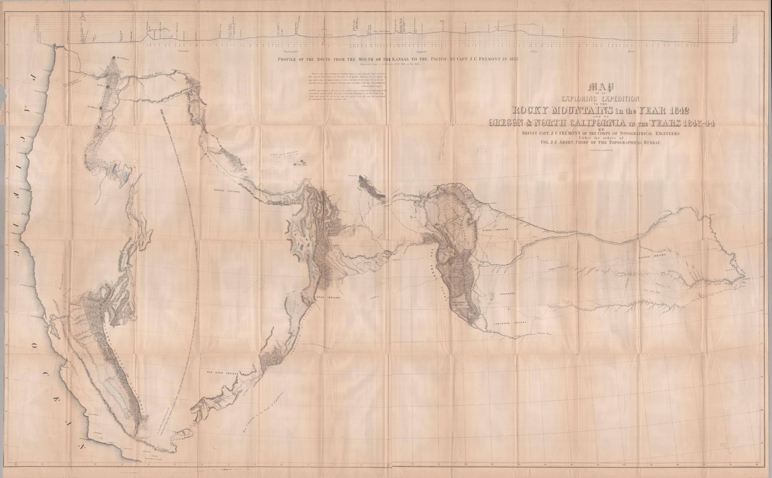
On February 20, 1844, the party was on the pass, at 9,338 feet by the temperature of boiling water, latitude 38° 44′, longitude 120° 28′, “1,000 miles by our travelled road from the Dalles of the Columbia.” Four days earlier the camp had been “on the head water of a little creek, where at last the water found its way to the Pacific.” He had a cause now. He gave it on page 235: at the edge of the continent, near the coast, a range of mountains higher than the Rocky Mountains themselves.
This extraordinary fact accounts for the Great Basin, and shows that there must be a system of small lakes and rivers here scattered over a flat country, and which the extended and lofty range of the Sierra Nevada prevents from escaping to the Pacific ocean.
He came down the west side, went south through California, and came back over the mountains in the spring. He had entered the pass, he wrote on page 254, “with a strong disposition” to travel directly across toward the Great Salt Lake, “in the view of obtaining some acquaintance with the interior of the Great Basin.” He took advice, and went around.
Page 276 walks the rim. The Wah-satch and Bear River mountains on the east. The Sierra Nevada on the west, “where we travelled for forty-two days.” A rim on the north, dividing the desert from the Columbia, and a rim on the south. “We entered the Basin at that point, and have travelled in it ever since.” “The existence of the Basin is therefore an established fact in my mind; its extent and contents are yet to be better ascertained. It cannot be less than four or five hundred miles each way.” The map says 11° of latitude, 10° of longitude. And, on the water: “where there is no outlet, there must be lakes to hold the accumulated waters, or sands to swallow them up.”
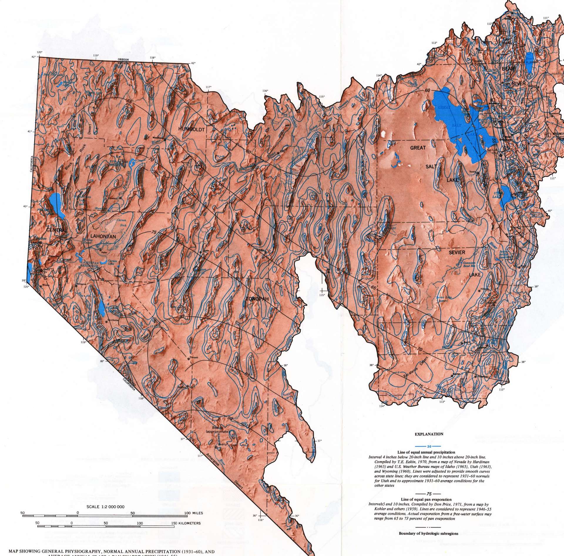
The Survey’s sheet of 1974 letters the subregions CENTRAL LAHONTAN, HUMBOLDT, GREAT SALT LAKE and SEVIER LAKE, and names Pyramid Lake and the Carson Sink. Its legend reads “Boundary of hydrologic subregions.” The line is drawn all the way round.
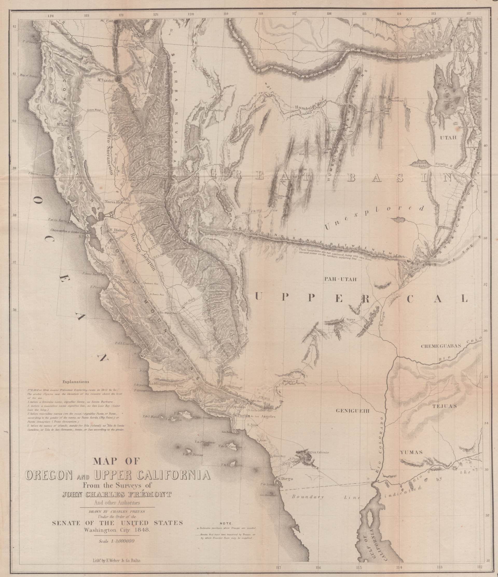
Preuss drew the country again in 1848, for the Senate, with the ranges drawn in. One word still stands across the southeast of it. Unexplored.
The water that goes over Llewellyn Falls is Silver King Creek. It runs into the East Fork of the Carson, and the East Fork into the Carson, and the Carson into the Carson Sink.
Sources
- John Charles Frémont, Report of the Exploring Expedition to the Rocky Mountains in the Year 1842, and to Oregon and North California in the Years 1843–’44. Washington: Gales and Seaton, 1845. pp. 175 · 196 · 219 · 225 · 226 · 235 · 254 · 276
- Charles Preuss, Map of an Exploring Expedition to the Rocky Mountains in the Year 1842 and to Oregon & North California in the Years 1843–44. Washington, 1845. The sheet, Library of Congress, Geography and Map Division.
- G. K. Gilbert, Lake Bonneville. U.S. Geological Survey Monograph 1, 1890, Plate II. The monograph, USGS Publications Warehouse.
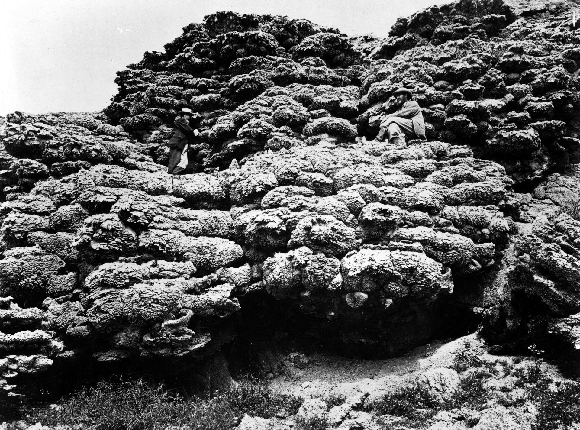
- Timothy H. O’Sullivan, Tufa formation, Anaho Island, Pyramid Lake, Nevada, 1867. Albumen print. The print, Library of Congress, Prints and Photographs Division.
- Don Price and T. E. Eakin, Hydrologic Investigations Atlas HA-487, sheet 1. U.S. Geological Survey, 1974. The atlas, USGS Publications Warehouse.
- Charles Preuss, Map of Oregon and Upper California from the Surveys of John Charles Frémont and other Authorities. Washington City, 1848. The sheet, Library of Congress.