The Friday Post · No. 6
Coleville
Listen · 9 min
Coleville is on a survey plat of 1874. Nine small marks stand for its buildings, three rows of three, on the west bank of the West Walker River. A road goes by them. John A. Benson and James R. Glover ran the lines. They were done on the last day of September. Jas. T. Stratton, the Surveyor General, signed it.
Across the river are the farms. “Kearney’s field.” “E. Barnett’s field.” “Harney’s field.” Below Harney’s, a “Ditch.” Forty acres in the corner of the section are shaded and marked “Swamp and Overflowed Land.” Down the valley forty more are shaded, with “Meadow Land subject to Overflow from Springs.”
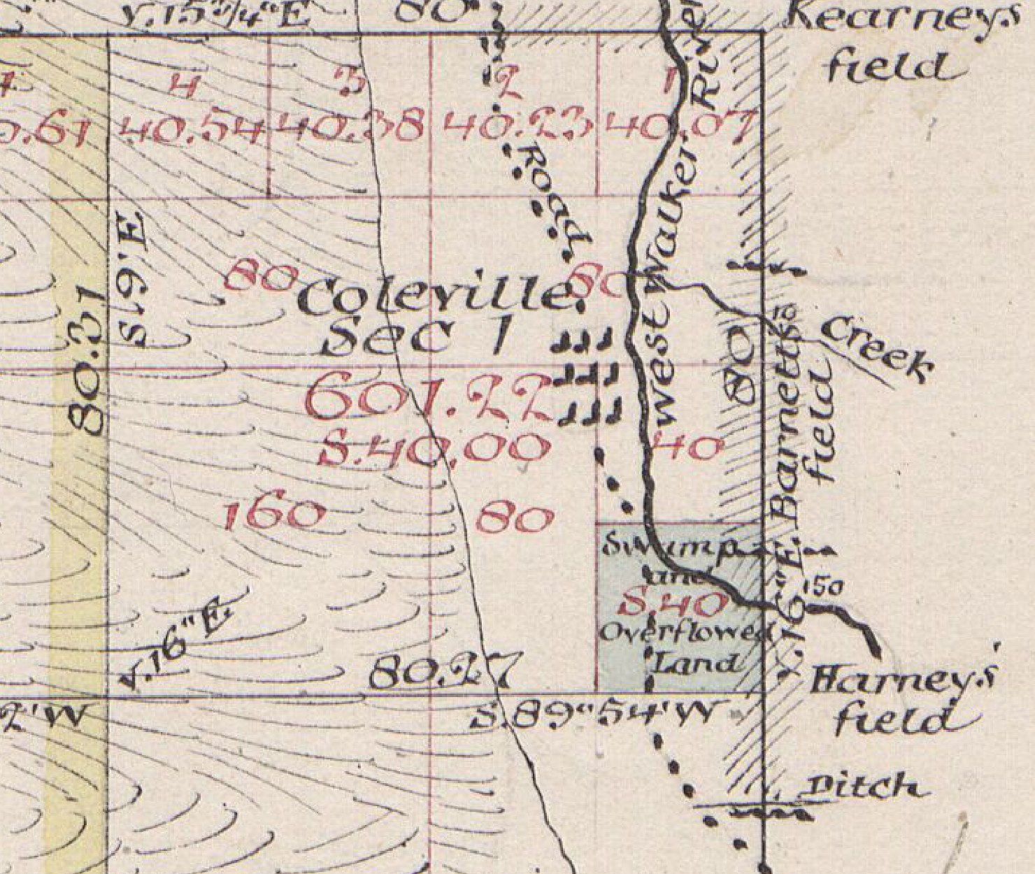
Anna M. Hartshorn bought land in that section for cash the next October. Daniel M. Barnett, Michael J. Carney, and Jasper M. Harney bought theirs on one day, November 10, 1877, in the section just over the township line where the fields lie. The plat says Kearney. The patent says Carney. The plat says E. Barnett. The patent says Daniel.
The Bodie Chapter of E Clampus Vitus and the Mono County supervisors set a plaque in town in 1966. It has the place founded by A. Horteshorne, called Centerville, Double Town, and Amonia, and named at last for Senator Cornelius Cole. The Northern Mono Chamber of Commerce tells it another way. Fred Cole, by its account, built a stage station, a blacksmith shop, and a store in 1867, and the town took his name soon after. I have found Fred Cole nowhere else. The plaque’s Horteshorne and the Land Office’s Anna M. Hartshorn share a section of ground and most of a name.
Walter N. Frickstad set the Mono County post offices in a table, in A Century of California Post Offices, page 104. His row reads “Coleville 23 Nov 1868,” and then a dash. The dash, his key says, means the office was still operating on the last day of December 1954.
The Wheeler Survey’s report for 1878 has an officer in Antelope Valley in October, “camping near Coleville, an agricultural hamlet. The West Walker flows through this valley, and furnishes the main supply of water for irrigation, the principal crops being hay and barley.” The survey’s road table brings a traveler in from Hoye’s Store, the Walker River post office and stage station, “to Coleville, via west side Antelope Valley (main route), 10.38 miles.” The wagon road up the east side, says the footnote, “is little traveled.”
The Barnetts kept a hotel. It burned early in 1896. The Record-Courier of Gardnerville dug the item out of its files forty years later, on March 13, 1936: “The Barnett hotel in Coleville burned to the ground last Friday. All the contents except a piano and one trunk were destroyed. The loss is estimated at $10,000.”
Wm. Hanlan drove the stage sleigh. In January 1907 he was nearing the post office when one of the braces broke and threw him and one passenger out. The Record-Courier called it “a lively runaway.” “The horses ran some distance before they were stopped. One horse was seriously hurt. With the exception of a few scratches, the driver and passenger escaped uninjured.”
Elizabeth Chichester lived alone a short distance south of Coleville. A neighbor saw her house burning at one in the morning. The Record-Courier of February 23, 1934, ran it across the front page: CHARRED REMAINS OF MRS. E. CHICHESTER FOUND IN RUINS OF HOME BURNED TO GROUND, and under it, HOLE IN SKULL GIVES SUPPORT TO BELIEF OF MURDER. Mono Sheriff Dolan and Coroner DeChambeau held an inquest and sent part of the skull to a laboratory in Berkeley. Somebody offered falling timber as the other explanation. The paper I have does not say what Berkeley found.
The Tracy resort burned in the fall of 1935. Tracy rebuilt it over the winter. On the first of May the Record-Courier announced COLEVILLE INN OPEN SUNDAY, a barbecue in the afternoon and a dance at night. “The new hotel building is modern in every particular and is a credit to Coleville and the determination of Mr. Tracy to make the best of a srushing blow.” So it is printed.
That same spring the school had more children than it had teachers, and nothing in the budget for a third. “The mothers’ club of the school stepped in,” the paper wrote in an editorial, “and during the term, has been raising funds through their own endeavor to pay the salary of the third teacher.”
CONSCIENTIOUS OBJECTORS CAMP CLOSED DOWN, the Record-Courier headed a front-page item on February 1, 1946. The Coleville camp, it said, “operated throughout the war,” and the men had been moved to Southern California. The summer before, more than a hundred of them had worked through the National Forest, and “from six to eighteen men were employed in the Alpine district during the summer repairing and building drift fences.” Robert Gardner, the district forest ranger, said none would work there that winter, “but he did not know if there were any plans to bring them back next summer.”
Four years after the camp closed, the telephones went to dial. “Antelope Valley and the little California community of Coleville soon will have communications of a par with those in the most metropolitan areas,” the Record-Courier wrote in February 1950. Twenty-two subscribers. The Interstate Telegraph Company put up “a brand new, pumice brick automatic exchange building” and strung its lines “from Sonnesyn’s resort on the south to the quarantine station on the California-Nevada line on the north.”
Somebody broke into the post office and the store next door one Monday in January 1955, between three and six in the morning. COLEVILLE P.O., GENERAL STORE LOOTED MONDAY, the Record-Courier headed it that Friday. About $300 left the store, and from the post office about $1,000 in cash, money orders, and stamps. The thief drove off in a Chevrolet pickup belonging to Bill Heron of Coleville. “The truck was found later that morning, badly wrecked and abandoned 300 feet off U. S. Highway 395, approximately 20 miles north of Coleville.” Deputy Sheriff Bob Whitlock was on the case.
Mae Dick James was born at Coleville on April 10, 1900, “to Washo and Minnie Jim Dick,” her obituary says. She went to school there. She married Roy James there in 1933. She died at Woodfords at ninety-three. The Land Office table carries Indian allotment patents in the Coleville section to Willie Rube and Eddie Rube, and to Henry Rube farther down the valley. It names no tribe.
The Geological Survey’s old Markleeville sheet letters “Alkali Lake” and “Little Alkali Lake” at the state line north of Coleville. Ira La Rivers, in Fishes and Fisheries of Nevada, page 156, writes that “the larger, present reservoir was formed by leading water in from the West Walker River in 1921-1922,” and that its 45,000 acre-feet were raised to nearly 60,000 with an earthfill levee at the south end. The lake took the name Topaz. Frickstad’s table closes the Topaz post office on October 14, 1922, its mail sent to Coleville. The reservoir had opened on the first of the month.
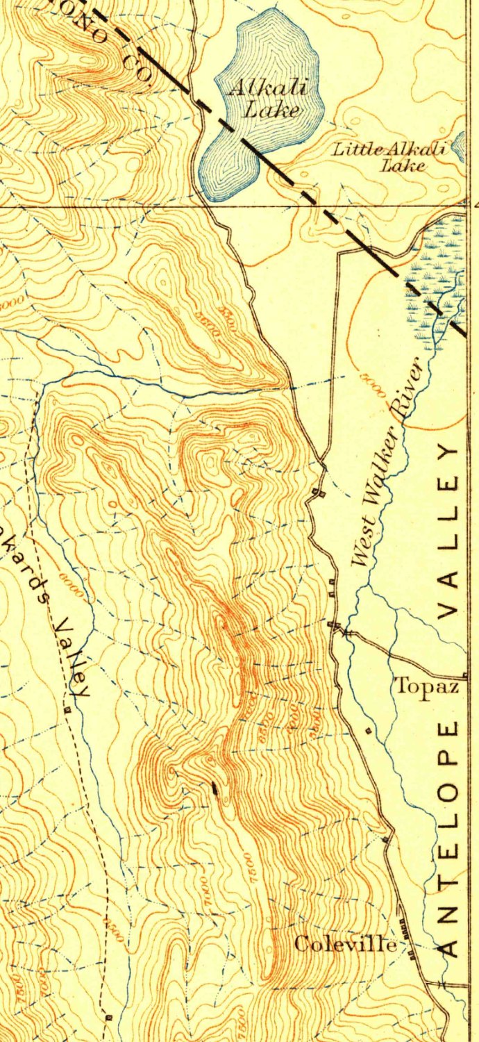
On the west side of the same plat, over the ridge, the draftsman lettered “East Fork of Carson River,” and across the summit, “Divide between Slinkards Creek and East Fork Carson River.” Coleville’s water is the West Walker, on the east side of the sheet. The Wheeler officer, camped by the hamlet that October, wrote down what he did next. “I next moved up the cañon of the West Walker, came out on the Sonora road, and returned to Bridgeport.”
Sources
- General Land Office, plat of Township 8 North, Range 22 East, Mount Diablo Meridian, surveyed 1874 by John A. Benson and James R. Glover, approved San Francisco, December 2, 1874, Jas. T. Stratton, Surveyor General. Bureau of Land Management, GLO Records.
- Bureau of Land Management, land patents, Mono County, California (FOIA extract, 1997).
- E Clampus Vitus, Bodie Chapter, with the Mono County Board of Supervisors, Coleville plaque, dedicated September 10, 1966. Transcription at noehill.com. noehill.com
- Northern Mono Chamber of Commerce, “Antelope Valley History.” northernmonochamber.com (page unreachable; wording from search-engine summary only; paraphrased, not quoted).
- Walter N. Frickstad, A Century of California Post Offices, 1848–1954. Oakland: Philatelic Research Society, 1955. Mono County, pp. 104–105, and the table key. archive.org, centuryofcalifor00fric, leaves n242 and n244.
- Annual Report of the Chief of Engineers for 1878, Appendix NN, Geographical Surveys West of the One Hundredth Meridian (Wheeler). Washington: GPO, 1878. P. 143.
- Geographical Surveys West of the One Hundredth Meridian, itinerary table, “From Bridgeport, Cal., to Mountain House, Nev., via East Walker River Road,” p. 174 and footnote.
- The Record-Courier, Gardnerville, Nevada. January 18, 1907, p. 4 · February 23, 1934, p. 1 · March 13, 1936, p. 4 · May 1, 1936, p. 1 · February 1, 1946, p. 1 · February 17, 1950, p. 1 · January 14, 1955, p. 1.
- United States Geological Survey, Markleeville sheet, California–Nevada, 1:125,000, surveyed 1889, edition of November 1893, reprinted 1916. USGS topoView 299442.
- Ira La Rivers, Fishes and Fisheries of Nevada. Carson City: Nevada State Fish and Game Commission, 1962. P. 156.
- “Nevada Appeal at 150: Oct. 1, 1922 — Topaz Lake celebration,” Northern Nevada Business Weekly, September 18, 2015. nnbw.com
- Mae Dick James, obituary, The Record-Courier (Alpine County clipping volume).